Be The First To Get Support Updates
Want to know about the latest technical content and software updates?
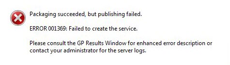
Error Message
Creating a web service and publishing the service to ArcGIS Server fails, and the following error is returned:
Packaging succeeded but publishing failed.

ERROR 001369: Failed to create the service.

Please consult the GP Results Window for enhanced error description or
contact your administrator for the server logs.
Cause
This is a generic error code. There are many different reasons why this error may occur.
The three most common causes of ERROR 001369 are related to:
- Permissions
- Data
- Memory
Two less common causes of the error are environment-specific, and are not present in all environments:
- OpLocks
- ArcGIS Workflow Manager for Server
Solution or Workaround
Before troubleshooting the error, review the ArcGIS Server logs. Logs give insight into what ArcGIS Server processes are taking place. The ArcGIS Server logs can be inspected in ArcGIS Server Manager, or directly on the machine where ArcGIS Server is installed.
To access the logs in ArcGIS Server Manager, click the Logs tab on the top-right.
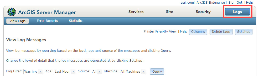
To access the logs directly on the machine where ArcGIS Server is installed, navigate to Drive:arcgisarcgisserverlogs.
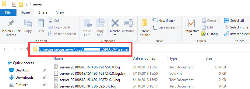
By default, the logs can be found in the ArcGIS Server directory.
Permissions
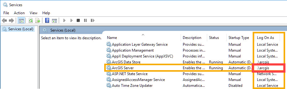
To investigate permissions, be familiar with the account running ArcGIS Server. If unsure about the details of the account, perform the following workflow.
- Open the Windows Services dialog (Start > enter Services). Or, open the Run desktop app, type services.msc, and click OK.
- Locate the ArcGIS Server service.
- Inspect the value in the Log On As column for this service.
- If the value is formatted like «.username«, ArcGIS Server is running under a local account. This means the account only exists on the machine where ArcGIS Server is installed.
- If the value is formatted like «DOMAINusername«, ArcGIS Server is running under a domain account. A domain account exists on the Windows domain.
In the following image, ArcGIS Server is run by a local account named ‘arcgis’; this is the default account when installing ArcGIS Server.
Once the account running ArcGIS Server is known:
- Ensure ArcGIS Server has read and write access on the following directories.
- C:Python27
- C:arcgisserver
- C:Program FilesArcGISServer
Note:
The above directories are the default directories. This list may vary depending on the environment.
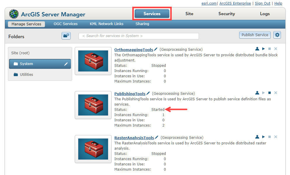
- Verify that the PublishingTools service has started. This can be checked in ArcGIS Server Manager by clicking the Services tab and viewing the PublishingTools service status.

- To further isolate the issue, answer the following questions:
- Is publishing possible at all?
- Can other data be published to ArcGIS Server?
- Is a service being overwritten, or was a service previously published with this same name? What happens if a new service, with a new name, is published instead?
Data
The result of the error may be data-specific. To determine if this is the case:
- Create a new MXD, add the data to the project, and publish it as a service.
- Re-register the data store being referenced in publishing.
Caution:
This workflow disrupts all services referencing the data source. Therefore, this workflow potentially brings down services and ruins data references until the data store is re-established.
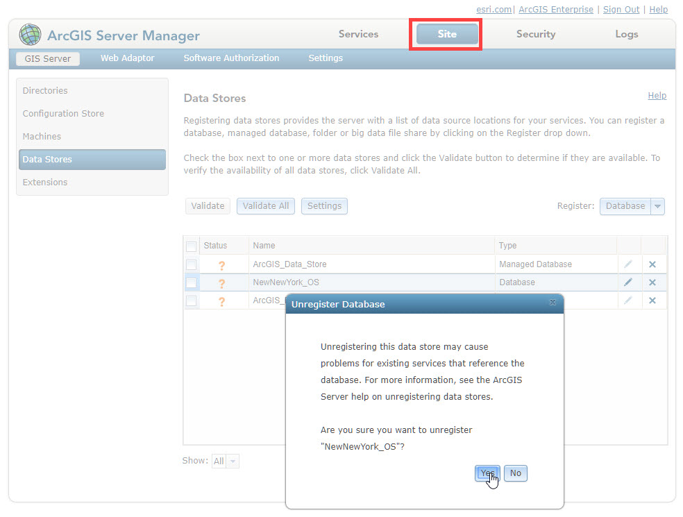
- In ArcGIS Server Manager, click the Site tab, and navigate to Data Stores.
- Click the X next to the data source to be re-registered.
- In the Unregister Database window, click Yes to delete the data connection.
- Click the Database drop-down and select the appropriate data source to re-establish the data store connection.
Memory
Check the number of ArcSOC processes. To check the number of ArcSOCs, log in to the machine where ArcGIS Server is installed.
- In a Windows environment, open Command Prompt and run the following command:
tasklist | find "ArcSOC.exe" /c
- In a Linux environment, run the following command:
ps -Al | grep -c arcso
If the number returned is greater than 200, this can be problematic in Windows environments. Refer to the linked article in the Related Information section below.
When possible, in either Windows or Linux environments, reduce the number of ArcSOCs. This can be done by:
- Tuning the service:
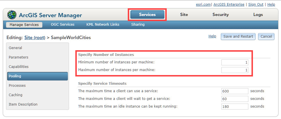
- In ArcGIS Server Manager, click the Services tab, and navigate to the service to be edited by clicking the pencil icon next to the service’s name.
- On the left-hand side, select Pooling.
- Lower the number of maximum instances for less popular services.
- Set the minimum number of instances for services not used regularly to ‘0’.
- Stopping any services that are not currently necessary.
- Deleting any services that are not necessary.
- Increasing heap size, as documented in the Related Information linked technical article.
Less Common Causes
- OpLocks
If the data referenced is a resource residing on a Samba directory with Opportunistic Locking (OpLocks) enabled, this error may be returned when publishing a service. To resolve this issue, disable oplocks for each of the Samba directories. The instructions provided describe how to do this.
- On the machine hosting Samba, open smb.conf.
- For each directory configured to be accessible through Samba, add the following properties:
[folder]
      ...
      oplocks = false
      level2 oplocks = false
      ...
- Save smb.conf.
- Run the testparm command to verify that the properties appear in the Samba configuration file.
- Restart Samba (SMB) and NetBIOS (NMB) services.
- ArcGIS Workflow Manager for Server
If ArcGIS Workflow Manager for Server has recently been installed, this error may be returned if:
- The ArcGIS Server service is not started.
- The ArcGIS Server or ArcGIS Workflow Manager for Server is not authorized.
- The user running the ArcGIS Server service is not a registered database user and does not have access.
- In a cluster ArcGIS Server environment, ArcGIS Workflow Manager for Server is not installed on all clusters.
- To troubleshoot this issue:
- Verify ArcGIS Workflow Manager for Server is installed, authorized, and accessible.
- Restart the ArcGIS Server service after ArcGIS Workflow Manager for Server is installed.
- If using Operating System authentication, add the acount running the ArcGIS Server services to the database with read and write permissions.
- Install ArcGIS Workflow Manager for Server on each cluster in the ArcGIS Server cluster environment.
Related Information
- ArcGIS Help: Tuning and configuring services
- Unable to publish new or start existing services when a large number of ArcSOC.exe processes are running
Last Published: 5/27/2020
Article ID: 000016577
I’m trying to publish a globe service on our ArcGIS Server and in ArcGlobe I get this error message
«Failed to publish service.«
—> Went to Results:
[h=1]001369 :
Failed to create the service.[/h] [h=2]Description[/h]The creation of
the service failed. This is a generic error. Many different conditions
could cause this failure. Check the server logs for the specific
issue.
[h=2]Solution[/h]Check the server logs for the specific issue.
—> Went to ArcGIS Server Logs:
SEVERE 22.08.2013, 10:15:20 Failed to construct instance of service
‘glob_4.GlobeServer’. Server SEVERE 22.08.2013, 10:15:20 Failed to
initialize server object ‘glob_4’: 0x80030003: null Server
SEVERE 22.08.2013, 10:15:20 (null) glob_4.GlobeServer
Unfortunately I really don’t know how to solve that. The service is published (I can see it on the server) but apparently it cannot start. I also tried saving a service definition file and then publishing it on the server-> same problem.
So thanks for any advice.
PS: We use ArcGIS Server 10.1 on Linux
Проблемы с публикацией сервиса
-
bullterrier
- Новоприбывший
- Сообщения: 5
- Зарегистрирован: 29 апр 2013, 11:54
- Репутация: 0
Проблемы с публикацией сервиса
Здравствуйте. Я работаю программистом в организации, использующей ArcGIS (пришел недавно, поэтому еще мало знаком с ArcGIS). Начальник дал задание опубликовать сервис, и при этом возникла проблема.
При попытке публикации любого картографического сервиса (даже простейшего, содержащего всего один слой) выскакивает ошибка «Ошибка публикации. ERROR 001369. Не удалось создать сервис». При этом в журнал ArcGIS Server Manager заносятся такие сообщения об ошибках:
1) SEVERE 17.07.2013 15:55:17 Ошибка выполнения инструмента.: ERROR 001369: Не удалось создать сервис. Не удалось выполнить (Publish Service Definition). System/PublishingTools.GPServer
2) SEVERE 17.07.2013 15:55:17 Не удалось создать сервис.: Unable to connect to all layers. System/PublishingTools.GPServer
3) SEVERE 17.07.2013 15:55:17 Не удалось настроить папку кэша для сервиса. System/PublishingTools.GPServer
На сервере установлен ArcGIS for Server 10.1 (установлен вчера, до него был 9.3, где проблем с публикацией сервисов не возникало). Похожей проблемы нигде не на форуме не нашел, в Google и Yandex тоже ничего найти не смог поэтому решил создать тему. Помогите, пожалуйста, разобраться.
-

novia
- Гуру
- Сообщения: 2261
- Зарегистрирован: 29 апр 2011, 15:06
- Репутация: 489
- Ваше звание: Модератор по ArcGIS
- Откуда: Москва
- Контактная информация:

Re: Проблемы с публикацией сервиса
Сообщение
novia » 17 июл 2013, 13:39
какой инструкцией пользовались при установке? (ссылку)
win? linux?
-
novia
- Гуру
- Сообщения: 2261
- Зарегистрирован: 29 апр 2011, 15:06
- Репутация: 489
- Ваше звание: Модератор по ArcGIS
- Откуда: Москва
- Контактная информация:
Re: Проблемы с публикацией сервиса
Сообщение
novia » 17 июл 2013, 14:04
в менеджер заходили? вижу что заходили
системные сервисы запущены?
доступ к ним не ограничен?
установку запускали от имени администратора?
сервис пак ставили?
-
bullterrier
- Новоприбывший
- Сообщения: 5
- Зарегистрирован: 29 апр 2013, 11:54
- Репутация: 0
Re: Проблемы с публикацией сервиса
Сообщение
bullterrier » 18 июл 2013, 06:05
novia писал(а):в менеджер заходили? вижу что заходили
системные сервисы запущены?
доступ к ним не ограничен?
установку запускали от имени администратора?сервис пак ставили?
Да, все системные сервисы запущены. Ограничений доступа и использования нет.
Устанавливал от имени администратора.
Сервис пак устанавливать не пришлось, так как использовался самый свежий установочный пакет, SP1 там уже есть.
Перепробовал уже все настройки кэширования, все равно не помогает. Сервис публикуется, только если выбрать пункт «просматривать динамически, по мере прочтения данных», т.е. не использовать листы кэша. Но в этом случае сервис не просматривается в ArcCatalog, поэтому нужно в любом случае использовать кэширование.
-
novia
- Гуру
- Сообщения: 2261
- Зарегистрирован: 29 апр 2011, 15:06
- Репутация: 489
- Ваше звание: Модератор по ArcGIS
- Откуда: Москва
- Контактная информация:
Re: Проблемы с публикацией сервиса
Сообщение
novia » 18 июл 2013, 08:21
попробуйте залогиниться от имени ArcGIS Account и создать/удалить файл в папке arcgiscache
-
bullterrier
- Новоприбывший
- Сообщения: 5
- Зарегистрирован: 29 апр 2013, 11:54
- Репутация: 0
Re: Проблемы с публикацией сервиса
Сообщение
bullterrier » 18 июл 2013, 10:29
novia писал(а):попробуйте залогиниться от имени ArcGIS Account и создать/удалить файл в папке arcgiscache
novia, спасибо Вам большое!
Я просто расширил права пользователя «arcgis», и все заработало.
Теперь возник еще один вопрос: в ArcGIS Server Manager 9.3 была возможность создания веб-приложения для .NET на основе сервиса (на языке C#.NET). А в 10.1 эта возможность куда-то исчезла. Подскажите, пожалуйста, как в 10.1 создать веб-приложение?
-
novia
- Гуру
- Сообщения: 2261
- Зарегистрирован: 29 апр 2011, 15:06
- Репутация: 489
- Ваше звание: Модератор по ArcGIS
- Откуда: Москва
- Контактная информация:
Re: Проблемы с публикацией сервиса
Сообщение
novia » 18 июл 2013, 10:52
novia, спасибо Вам большое!
Я просто расширил права пользователя «arcgis», и все заработало.
зато до этого писали, что
bullterrier писал(а):
При установке инструкциями особо не пользовался, там ведь в принципе все понятно. Сначала удалил 9.3 и очистил сервер от всего, что с ним связано, после чего произвел установку 10.1. при установке пару раз заглядывал сюда:
http://resources.arcgis.com/ru/help/ins … 005000000/
надо было не пару раз заглянуть, а хотя бы прочесть вот это
-
novia
- Гуру
- Сообщения: 2261
- Зарегистрирован: 29 апр 2011, 15:06
- Репутация: 489
- Ваше звание: Модератор по ArcGIS
- Откуда: Москва
- Контактная информация:
Re: Проблемы с публикацией сервиса
Сообщение
novia » 18 июл 2013, 10:56
bullterrier писал(а):
Теперь возник еще один вопрос: в ArcGIS Server Manager 9.3 была возможность создания веб-приложения для .NET на основе сервиса (на языке C#.NET). А в 10.1 эта возможность куда-то исчезла. Подскажите, пожалуйста, как в 10.1 создать веб-приложение?
вам нужно установить компонент Web ADF, который теперь вынесен отдельно и не ставится по умолчанию.
но в 10.2 (выходит в этом году) конструктора приложений «как раньше» уже не будет. будут только Viewer для Flex и Silverlight, и различные API
так что задумайтесь о переходе на новые рельсы уже сегодня. настройка вьюеров проста до нельзя, а умеют они «из коробки» больше, чем то, что было раньше.
Recently I posted a service and encountered many errors of 001369, but check the help document. In summary, this is a common error and requires specific analysis of specific problems. This is like executing the GP tool in ArcMap and encountering 99999 Errors are the same, and can only be judged by experience. Then I will sort out the error 001369, from which aspects can I troubleshoot.
First, you should go to the manager page of the server to query the log. It is faster to locate it through the log. Then control the following solutions to solve them.
Windows and Linux are the same, compare by yourself
1. Authority issue: the following three positions need to be givenArcGIS Server Account account full control permissions, Respectively (Server installation directory, Server configuration directory, Python27 folder)
2.Is the publishing tool activated:2.1 You can log in to the manager page of Server, click on the service-management service-System folder, find the PublishingTools tool, and see if it is started (applicable to 10.2-10.4 version)
2.2 Log in to the admin page of Server, click Service-System-FindPublishingToolsTool, click the tool, click the status button below to see if its status is started
Find out the same reasonPublishingToolsExTool, click the tool, click the status button below to see if its status is started
If any of the above two states is not started, you need to stop and then restart the tool. If the startup fails, you need to go to the server’s manager page to see the cause of the startup failure. (Applicable to version 10.5 and above)
Some versions of PublishTools failed to start because of Microsoft security patches, and the corresponding patches need to be installed, The address is as follows: https://support.esri.com/zh-cn/download/7576
3.Change to mxd documentCan it be published successfully?
4. The same dataChange data sourceCan it be published successfully?
5.Is there a service with the same name? Or a service with duplicate aliases?
6. If the data storage is registered, thenregister againTake a look, see if you can register, and then post the service. If it is a copied data source, then thisThe folder or database where the data is located is registered to the Server。
7. Check the number of processes. In the Windows environment, open the cmd window and enter tasklist | find «ArcSOC.exe» /c In the Linux environment, enter ps -Al | grep -c arcso If the number returned is greater than 200, then in the Windows environment There may be problems in the Windows or Linux environment, if possible,Reduce the number of ArcSOC, You can modify the number of instances to change the minimum number of infrequently used services to 0, and change the maximum number of instances of services with low traffic to smaller. You can also choose to stop any services that are not currently needed, delete unnecessary services, and increase the heap size.
8. If the same data source and the same mxd file are found, whenCan publish successfully when the number of layers is relatively small, If the number of layers is too large, it will not be able to send, except for 001369, there is no other error message, then you can try to publish the service beforeRelease the map after zooming in to a larger scale。
9. Communication issues. 9.1 IfServer, database on cloud machine, The machine where ArcMap is located is an ordinary physical machine. Then the server where the server is located actually has two ips, one ip is the internal ip of the machine, which can be viewed through ipconfig or ifconfig commands, and the other is an external ip, which is told by the cloud machine provider, then release When feature service, you need to register the database to the Server, where,The publisher database connection uses the external ip to connect to the database, uncheck Same as publisher database connection, and use the internal ip to connect to the database in the Server database connection
9.2 Check the machine where ArcMap and Server are located,Clear the IPv4 DNS information on the machine
10. Coordinate system problem. changeData source coordinate system
11.The sde database does not match the Server version
12. Database permissions issues. When publishing a 3D model, it will fail if it prompts that the relational database is in read-only mode. You need to check whether the disk space is sufficient.In the case of ensuring sufficient disk space, use changedatastoremode readwrite to change to read-write mode
13.Upgrade IE11
14. If the newly released service can succeed, but covering the original service will fail.Restart the machineTry it. ,
15. If the referenced data is a resource on the Samba directory and OpLocks is turned on, it will also cause the publishing service to fail, because oplock needs to be disabled for each Samba directory. The steps are as follows: On the machine hosting Samba, open the smb.conf file, and for each directory configured to be accessible through Samba, add the following attributes
……

oplocks=false

level2 oplocks =false

……
Save smb.conf. Run the testparm command to verify that the attributes appear in the Samba configuration file. Restart the Samba (SMB) and NetBIOS (NMB) services.
16. How to newly install ArcGIS Workflow Manager for Server, when the following errors occur, the error 001369 will also be returned, which are
The ArcGIS Server service is not started.
ArcGIS Server or ArcGIS Workflow Manager for Server is not authorized.
The user running the ArcGIS Server service is not a registered database user and does not have access rights.
In a clustered ArcGIS Server environment, not all clusters have ArcGIS Workflow Manager for Server installed.
17. The issue of piracy. If there is any pirated version of the software used, this problem may occur

Проблемы, возникающие при публикации сервисов после установки arcgisservice:
Решение:
1) Остановите службу сервера arcgis.
2) Удалите файлы блокировки (* .glock и * .rlock) в arcgisserver config-store.
3) Перезапустите службу сервера arcgis.
4) Остановите службу ожидающей остановки и запустите ее.
Просто переиздайте
Ниже приведены причины, найденные в Интернете;
По моему опыту, удаление файла .glock не имеет непредвиденных последствий для системы / ArcGIS Server, хотя это всегда делается в крайнем случае и хирургическим путем (т. Е. Удаление файла .glock только для одной службы блокировки). После удаления этих файлов вы можете управлять связанными службами и возвращать их в рабочее состояние.
Вы можете столкнуться с ситуацией, когда Java-процесс ArcGIS Server (javaw.exe) привязан к файлу .glock, что не позволит вам удалить его. В этом случае вам придется перезапустить ArcGIS Server (чтобы освободить его перехватчики в файле) или использовать инструмент «kludgy», чтобы принудительно установить ту же версию. Конечно, если вы работаете в производственной среде, перезапуск ArcGIS Server не является вариантом, вам, возможно, придется прибегнуть кТакойинструмент. К
В соответствующих инструкциях указан номер ошибки для этой проблемы (NIM100965: «Запуск службы с минимальным количеством экземпляров 0 приведет к тому, что блокировка службы не будет снята, когда служба будет использована при запуске») и »Список решений проблем »Сообщите об этом как исправлено в 10.3.
Создав высокоизолированный картографический сервис с 0 минимальным количеством экземпляров, а затем быстро перезагрузив URL-адрес WSDL сервиса при запуске сервиса, я смог воспроизвести проблему на исходном сервере и установить ArcGIS Server (10.2.1).
Возможность устранения взаимоблокировки на ArcGIS Server путем удаления любых файлов .glock в каталоге «locks» в хранилище конфигурации для получения сервисов.
I’m not 100% sure but I think the reason why I cannot publish the globe service is because we don’t have the ArcGIS Image Extension for Server. «The ArcGIS Image extension is also required when publishing a globe document containing a mosaic dataset or raster layer»
My globe service contained a polygon feature class, and I extruded the features.
Not only we don’t have the Image Extension but apparently it doesn’t run on Linux either.
So I’m not sure if this is the cause, but please support or contradict my answer.
It appears ESRI has been retiring their old free geocoding services, such as the one at http://tasks.arcgisonline.com/ArcGIS/rest/services/Locators/TA_Streets_US/GeocodeServer, as described if you visit that URL in a browser. I’ve found them to be up one minute, down the next, more often the latter as time goes on in the past week.
Anyway, the new ones are still free for certain use cases (like ‘enter an address, zoom to it’ as described here — basically any use other than batch geocoding), so in my case, with no ArcGIS Online subscription, a simple change from the old URL to the new one made my app work again, no other modifications needed. The new URL is:
http://geocode.arcgis.com/arcgis/rest/services/World/GeocodeServer
If you go to that URL in a browser, it seems like you can’t use it, but that is just because the Services Directory is disabled. An actual query will work — like go to this URL in a browser, you receive the answer:
http://geocode.arcgis.com/arcgis/rest/services/World/GeocodeServer/find?text=380+New+York+Street%2C+Redlands%2C+CA+92373&f=pjson
And the help for the new service, like how to use your subscription to do batch geocoding, is here.
Here’s an example of what I’m doing, in Silverlight — hope it helps!
search address string as typed by the user: «101 s webster st madison wi«
my code snippet similar to yours:
            ESRI.ArcGIS.Client.Tasks.Locator locatorTask = new ESRI.ArcGIS.Client.Tasks.Locator
            {
                Url = locatorConfig.ArcGISLocator.RESTURL,
                ProxyURL = locatorConfig.ArcGISLocator.ProxyURL,
                Token = locatorConfig.ArcGISLocator.Token
            };
            locatorTask.AddressToLocationsCompleted += new EventHandler<ESRI.ArcGIS.Client.Tasks.AddressToLocationsEventArgs>(ArcGISLocator_GeocodeCompleted);
            locatorTask.Failed += new EventHandler<TaskFailedEventArgs>(ArcGISLocator_GeocodeFailed);
            AddressToLocationsParameters addressParams = new AddressToLocationsParameters();
            ArcGISLocatorParams paramFields = locatorConfig.ArcGISLocator.ParameterFields;

            if (!string.IsNullOrEmpty(paramFields.AddressField)) addressParams.Address.Add(paramFields.AddressField, address);
            if (!string.IsNullOrEmpty(paramFields.CityField)) addressParams.Address.Add(paramFields.CityField, city);
            if (!string.IsNullOrEmpty(paramFields.StateField)) addressParams.Address.Add(paramFields.StateField, state);
            if (!string.IsNullOrEmpty(paramFields.ZipField)) addressParams.Address.Add(paramFields.ZipField, zipCode);
            if (!string.IsNullOrEmpty(paramFields.CountryField)) addressParams.Address.Add(paramFields.CountryField, country);

            locatorTask.AddressToLocationsAsync(addressParams);
the values of the locatorConfig properties you see in the snippet:
- ArcGISLocator.RESTURL: «http://geocode.arcgis.com/arcgis/rest/services/World/GeocodeServer»
- ArcGISLocator.ProxyURL: «»
- ArcGISLocator.Token: «»
- paramFields.AddressField: «Address»
- paramFields.CityField: «City»
- paramFields.StateField: «State»
- paramFields.ZipField: «Zip»
- paramFields.CountryField: «Country»
The values of variables you see near the end of the snippet, parsed out of that address string:
- address: «101 s webster st»
- city: «madison»
- state: «wi»
- zipCode: «»
- country: «»
And the request sent, grabbed from Fiddler:
GET http://geocode.arcgis.com/arcgis/rest/services/World/GeocodeServer/findAddressCandidates?Address=+101+s+webster+st&City=madison&State=wi&Zip=&Country=&f=json& HTTP/1.1
and the response JSON, by pasting that URL into a browser address bar:
{"spatialReference":{"wkid":4326,"latestWkid":4326},"candidates":[{"address":"101 S Webster St, Madison, Wisconsin, 53703","location":{"x":-89.380682603118885,"y":43.075083755112303},"score":100,"attributes":{}},{"address":"101 S Webster St, Madison, Wisconsin, 53703","location":{"x":-89.380801995315039,"y":43.075177953700688},"score":100,"attributes":{}},{"address":"101 N Webster St, Madison, Wisconsin, 53703","location":{"x":-89.383269776378313,"y":43.077020734720236},"score":92.430000000000007,"attributes":{}},{"address":"101 W Webster St, Madison, Tennessee, 37115","location":{"x":-86.717820077333897,"y":36.251970064368038},"score":92.430000000000007,"attributes":{}},{"address":"101 E Webster St, Madison, Tennessee, 37115","location":{"x":-86.717069182995601,"y":36.251749462468808},"score":92.430000000000007,"attributes":{}},{"address":"101 Webster Cir, Madison, Mississippi, 39110","location":{"x":-90.143067048604621,"y":32.471797799230103},"score":83.349999999999994,"attributes":{}},{"address":"102 S Webster St, Madison, Wisconsin, 53703","location":{"x":-89.380875912392696,"y":43.075155601051222},"score":79,"attributes":{}},{"address":"S Webster St, Madison, Wisconsin, 53703","location":{"x":-89.38031660062984,"y":43.074651800841025},"score":100,"attributes":{}},{"address":"Webster St, Madison, Illinois, 62060","location":{"x":-90.169549322842215,"y":38.681054079683122},"score":90.540000000000006,"attributes":{}},{"address":"N Webster St, Madison, Wisconsin, 53703","location":{"x":-89.382136680062956,"y":43.076082179749903},"score":90.540000000000006,"attributes":{}},{"address":"W Webster St, Madison, Tennessee, 37115","location":{"x":-86.717738909022671,"y":36.251902749213571},"score":90.540000000000006,"attributes":{}},{"address":"E Webster St, Madison, Tennessee, 37115","location":{"x":-86.715515843380672,"y":36.251021493648068},"score":90.540000000000006,"attributes":{}}]}